The Geology of the Yorkshire Coast
Posted on
The East Yorkshire Coast is varied in character due to the local geology and past climatic history and will continue to evolve as we move into a period of global warming.
Starting at Scarborough, the coast is dominated by the limestones, clays and sandstones of the Middle and Upper Jurassic, which form the cliffs and bays associated with the town and its castle. These rocks continue to outcrop through Cayton Bay, finally being faulted out at Filey Brigg (Figure 1) where, from Roman times, the Upper Jurassic calcareous grits were quarried for building stone.
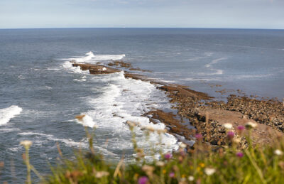
Fig. 1: Filey Brigg – photo by R. Myerscough
Moving south into Filey Bay, the soft clays of the Upper Jurassic and Lower Cretaceous form a wide bay of crumbling cliffs that are nationally and internationally famous for their fossil content. In pre-glacial times this was the exit of the proto-River Derwent before its course out of the Vale of Pickering was altered by glacial activity. At the southern end of the bay the Upper Cretaceous Chalk rises out of the sea to form the spectacular 100-metre Bempton Cliffs famous for the seabird colonies. Flamborough Head (Figure 2) exposes the most northerly chalk in England, which was faulted, folded and generally distorted by the last Alpine Orogeny with the result that it is so hard that the headland is resistant to erosion, whilst the many faults are lines of weakness allowing the sea to erode the many caves, coves, stacks and arches. The hardness of this northern chalk has also produced a good building stone to be seen in local Flamborough houses as well as the castle and the old Chalk Tower.
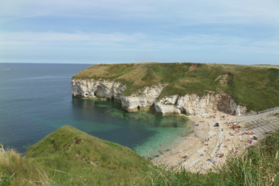
Fig. 2: Flamborough Head – photo by R. Myerscough
Away from the main fault zone, the chalk becomes softer with straighter cliffs which are less favourable to seabirds for nesting sites. The chalk eventually is cut off by the clays, sands and gravels deposited by the last Ice Age which cover the internationally important Sewerby Buried Cliff formed in a warming stage during the Ice Age – when sea levels were at least six metres higher than today and the cliffs stretched down the edge of the Wolds into Lincolnshire.
From Bridlington to Spurn Point the coastline is dominated by these soft sediments from the cold phases of the Ice Age to form the fastest eroding coastline in Europe. In time, Holderness will be eroded away back to the old cliff line. This rate of erosion is being accelerated by rising sea levels and land sinking. At the end of the Ice Age, sea levels were some 50 metres below their present levels and the North Sea basin was uncovered to form a land area known as Doggerland – of which Holderness is the last remnant. Bands of hunter-gatherers moved across this landscape and evidence for their tools and camp sites can be found scattered across the Yorkshire Wolds, the Vale of Pickering and Holderness.
The story of our coast finishes at Spurn Point which is a spit built of material washed down the coast by longshore drift and a rhythmic history of growth and destruction. The beaches of Spurn and Holderness bear witness to the past with glacial erratics: rocks carried from Northern England, Scandinavia and rocks from the start of our journey.
Richard Myerscough, July 2023
PLACE / East Yorkshire Geopark
To download a pdf version of the article for reading offline CLICK HERE